
9am AST, 2 July, 2024
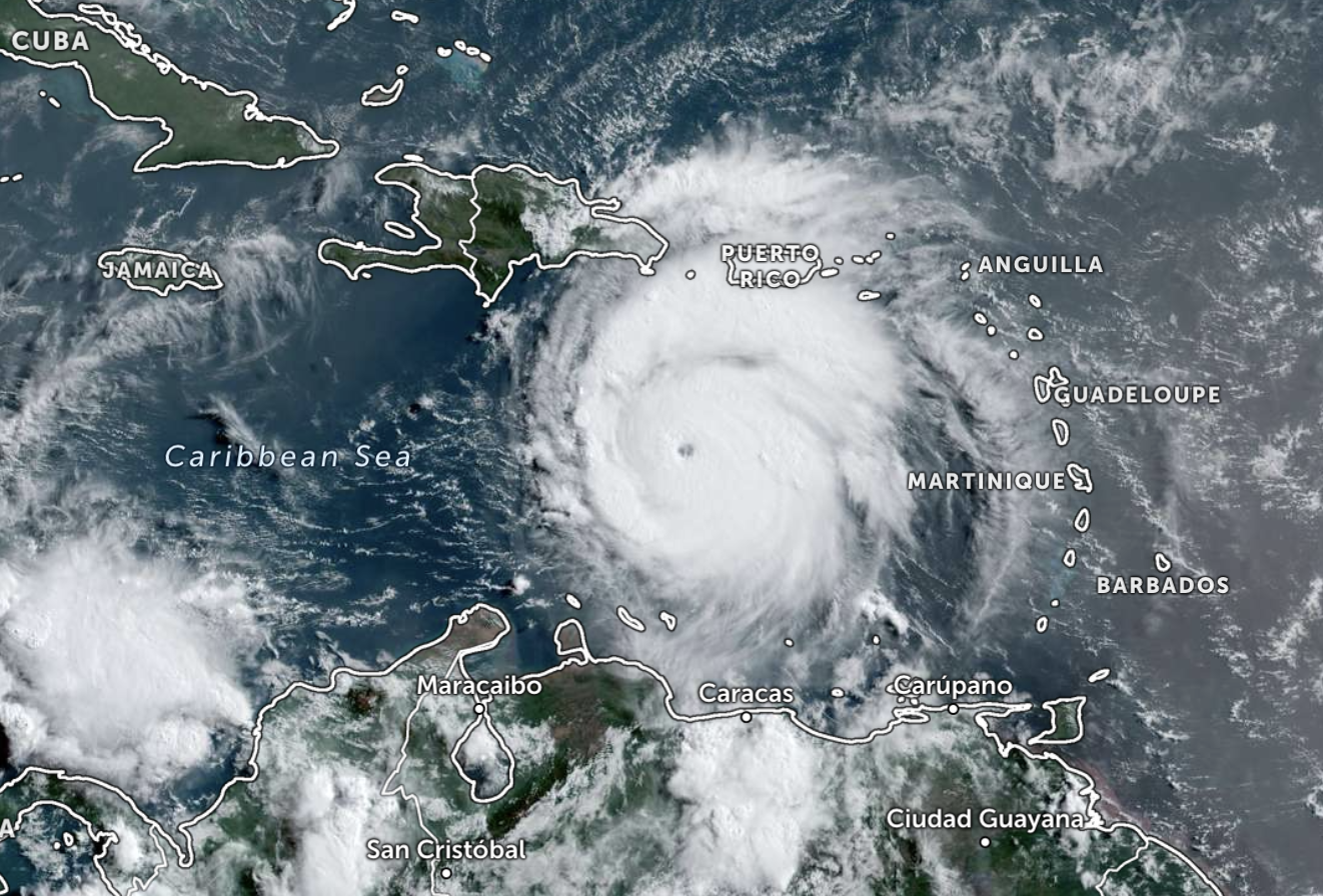
After devastating several islands in the southeastern Caribbean, Hurricane Beryl continues to head west, now as a Category 5 storm with sustained winds of up to 165 miles per hour.
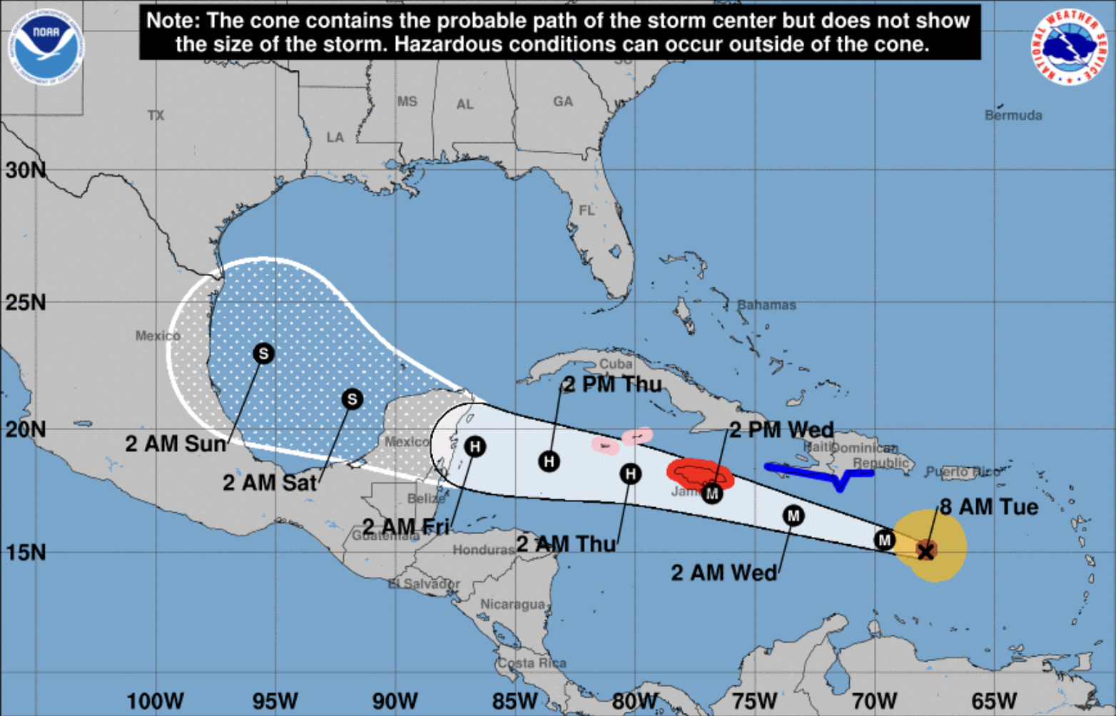
The cyclone is barrelling across the Caribbean Sea towards Jamaica at a speed of 22mph and is expected to make landfall as a major Category 3 storm on Wednesday morning.
The Cayman Islands is also in the current forecast path of Beryl, which is expected to arrive as a Category 2 hurricane early on Thursday morning.
The second named storm of the Atlantic hurricane season has already brought catastrophic winds, life-threatening storm surges and damaging waves, along with heavy rainfall to the Caribbean.
The smaller islands in St Vincent and the Grenadines, and Grenada have been the worst hit, with Tobago, Barbados, St Lucia, Martinique and Dominica also reeling from the effects of the storm.
A hurricane warning is now in effect for Jamaica where the National Hurricane Center (NHC) urges residents to rush to complete preparations to protect life and property.
Further west, the Cayman Islands has been put under a hurricane watch, while the south coast of the Dominican Republic and the south coast of Haiti are under tropical storm warnings.
Quickly evolving
In an NHC forecast published at 5am, 2 July, the centre said Beryl remains an “impressive” Category 5 hurricane this morning with a well-defined eye, but its intensity forecast is uncertain.
“Model guidance all indicates that the hurricane will begin to weaken later today as Beryl encounters moderate-to-strong vertical wind shear,” it said.
“Later on, factors such as the possible interaction with the Jamaican elevated terrain, dry air intrusions, and the structure of the vertical wind shear will all play a role in the rate of weakening.”
Currently, hurricane-force winds are extending up to 40 miles from the centre and tropical-storm-force winds extend outward up to 125 miles.
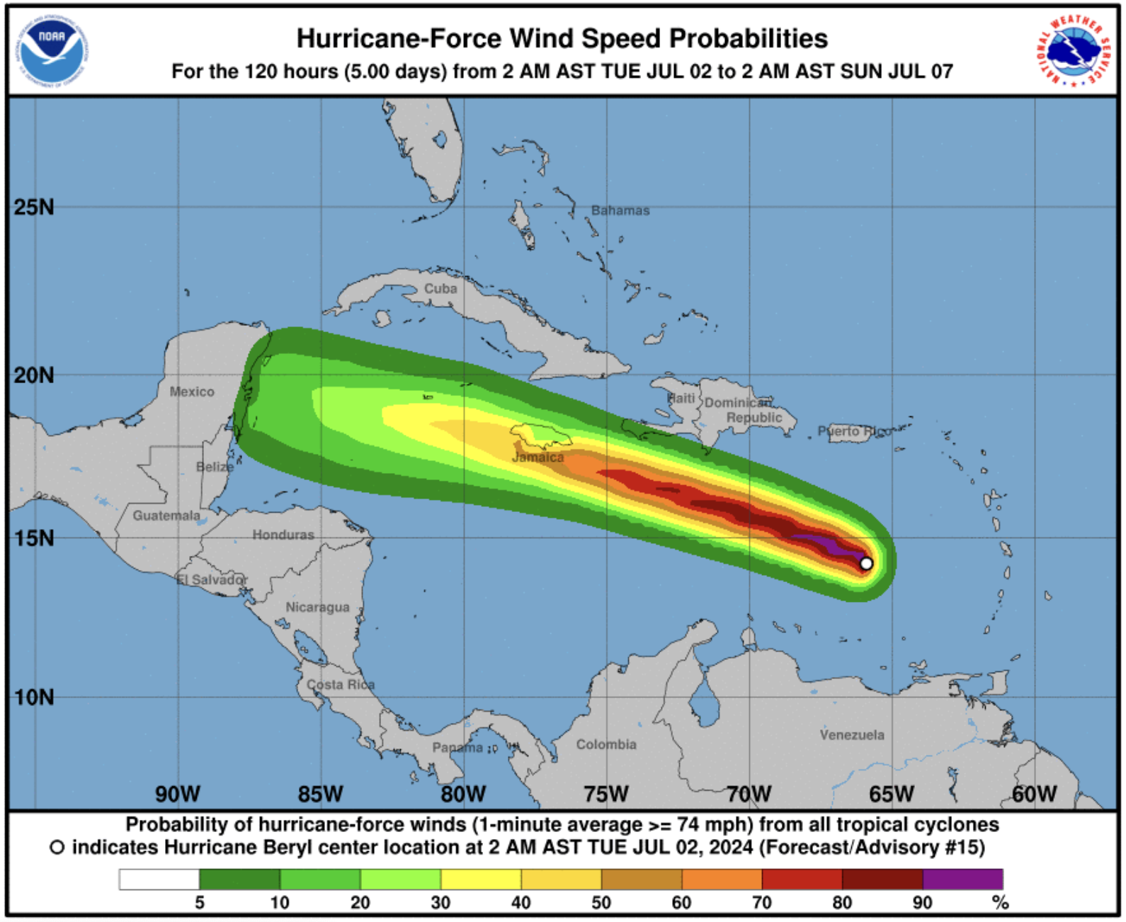
Forecasters expect life-threatening storm surges in Jamaica which may raise water levels by as much as six feet above normal tide levels.
Near the coast, the surge will be accompanied by large and destructive waves, the hurricane centre added.
Beryl is forecast to produce rainfall of four to eight inches, with localised maximum of 12 inches, across Jamaica with potential flash flooding.
Large swells will continue across the Windward and southern Leeward Islands during the next couple of days.
The centre also expects swells to reach the southern coasts of Puerto Rico and Hispaniola later today. These swells are expected to cause life-threatening surf and rip current conditions.
Above average
In May, the National Oceanic and Atmospheric Administration (NOAA) predicted an above normal Atlantic hurricane season. This takes place from June 1 to November 30.
Experts forecast a range of 17 to 25 total named storms with winds of 39 miles per hour or higher. They expect eight to 13 to become hurricanes, with winds of 74 miles per hour or higher.
Of those, they have forecast four to seven to be major hurricanes, of category three, four or five, with winds of 111 miles per hour or higher.
Montserrat’s Disaster Management Coordination Agency (DMCA) director Alvin Ryan, in a Facebook video message on 1 June, urged residents to prepare.
“Action now can really help reduce the impacts of storms on our communities, reduce damage to property, and most importantly, save lives, which is the ultimate goal,” he said.
“Remember, it only takes one.”
Information on how to prepare for a hurricane is available in the DMCA’s 2024 Hurricane Preparedness Guide here.
Visit the National Hurricane Center for the latest weather updates at www.nhc.noaa.gov