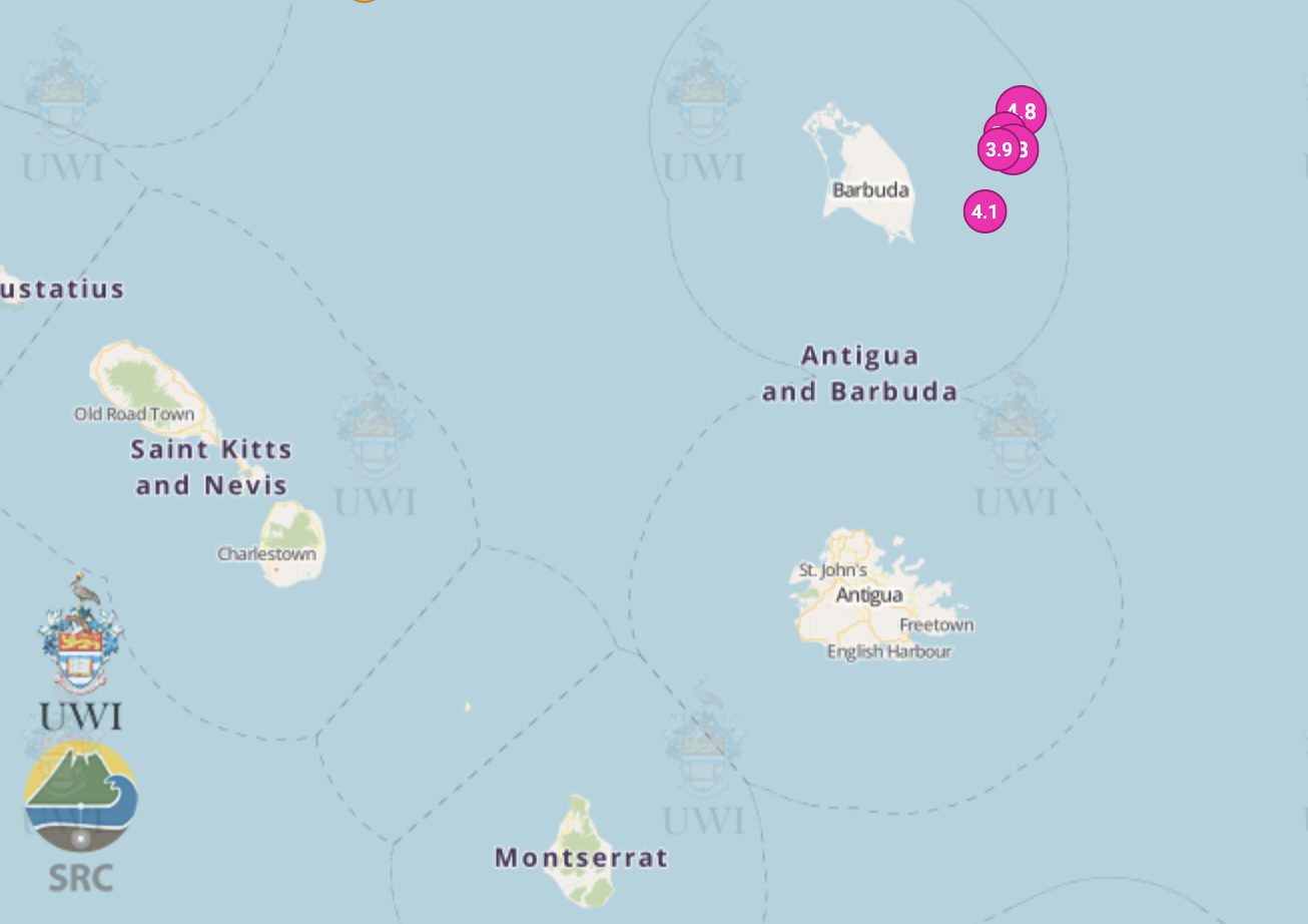
Five earthquakes have been recorded near Barbuda since yesterday afternoon, with the latest being a magnitude 4.4 event that struck just before 6am this morning.
The quakes were measured at between 3.7 and 5, or minor to moderate, on the Richter scale, meaning they are likely to be felt nearby and may cause small amounts of damage to weak structures only.
Numerous neighbouring island residents felt the seismic events, including in Antigua, Montserrat and St Kitts and Nevis.
The University of West Indies Seismic Research Centre detailed all of the five earthquakes on its Facebook page throughout the night.
The first and largest was a magnitude 5 recorded at 5.11pm on 15 November, at a depth of 15 kilometres.
It was located 60km north east of Saint John’s in Antigua and Barbuda, 110km north east of Brades in Montserrat, and 126km east north east of Basseterre in Saint Kitts and Nevis.
The second event was a magnitude 4 earthquake recorded just over an hour later at 6.32pm, at a depth of 14 km.
It was located 55km north north east of Saint John’s in Antigua and Barbuda, 105km north east of Brades in Montserrat, and 121km east north east of Basseterre in Saint Kitts and Nevis.
The third earthquake was magnitude 3.7 and was recorded less than an hour later at 7.11pm, at a depth of 18km.
It was located 73km north east of Saint John’s in Antigua and Barbuda, 123km north east of Brades in Montserrat, and 136km north east of Basseterre in Saint Kitts and Nevis.
The fourth event was a magnitude 3.8 earthquake recorded at 12.26am on 16 November, at a depth of 17km.
It was located 62km north east of Saint John’s in Antigua and Barbuda, 113km north east of Brades in Montserrat, and 128km east north east of Basseterre in Saint Kitts and Nevis.
The fifth and most recent earthquake was recorded at 5.48am at a magnitude of 4.4 and a depth of 14km.
It was located 67km north east of Saint John’s in Antigua and Barbuda, 117km north east of Brades in Montserrat, and 132km east north east of Basseterre in Saint Kitts and Nevis.
According to the University of West Indies Seismic Research Centre, the eastern Caribbean is an example of an island arc system formed at a subduction zone on a convergent plate boundary.
This means that two tectonic plates meet and the denser plate is forced beneath the lighter plate, creating the main cause of the volcanic and seismic activity in the area.
There has not been an earthquake disaster in the region since 1843, when an earthquake struck between Antigua and Guadeloupe.
It caused considerable destruction to islands from Saba to Dominica and nearly 2,000 deaths, mainly in Guadeloupe.
Watch the video below to learn more about earthquakes and volcanos in the region:
Guidance on how to plan and prepare for earthquakes is available on the UWI Seismic Research Centre website here.
Guidance on how to plan and prepare for volcanic activity is available on the Montserrat Volcano Observatory website here.


