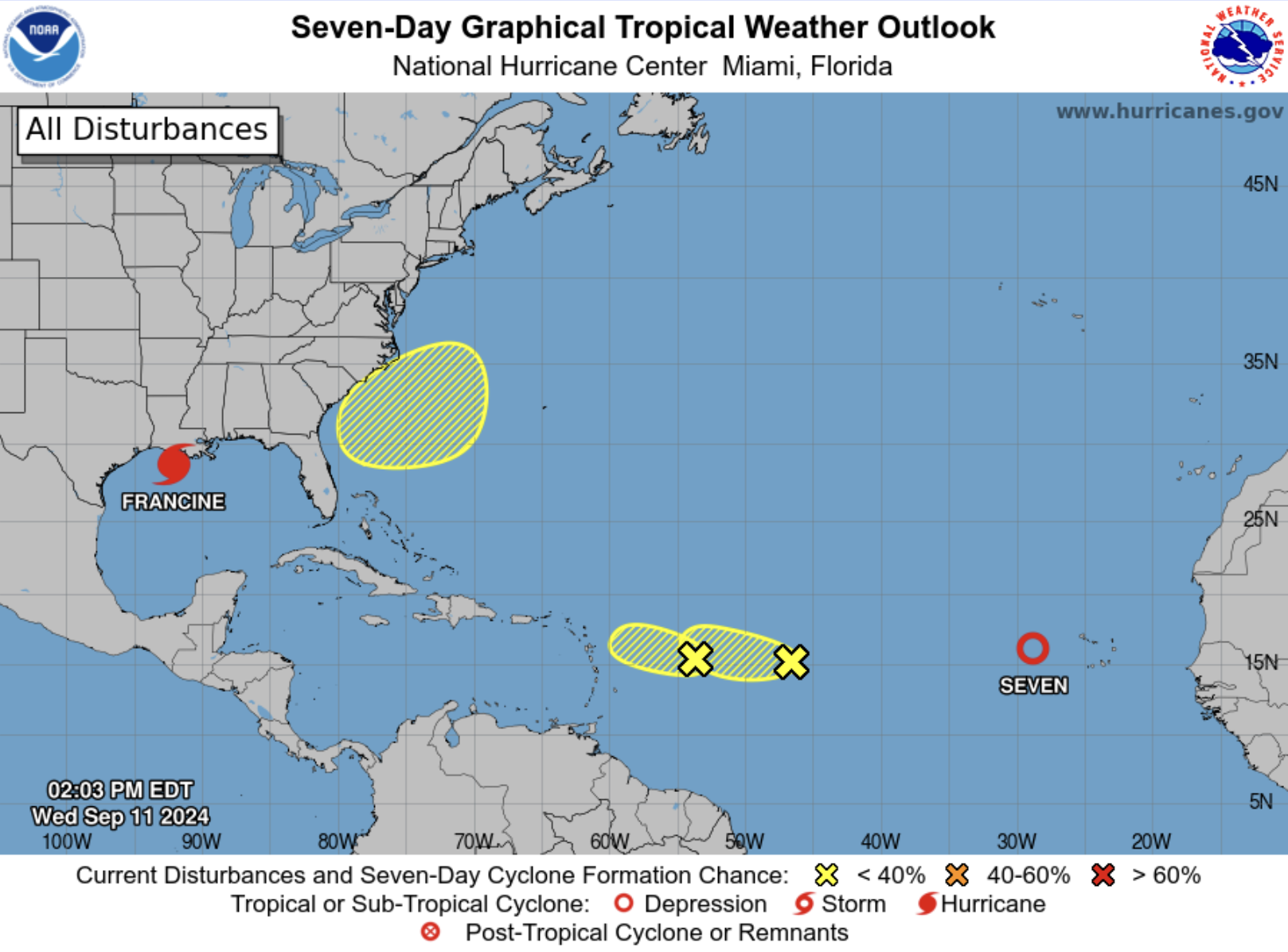
11 September, 3.30pm:
Two areas of low pressure that are heading towards the northern Caribbean are unlikely to form into cyclones before reaching the region – but may bring some bad weather.
Montserrat’s Disaster Management Coordination Agency (DMCA) said in a Facebook post that neither system poses an immediate threat to Montserrat.
According to a 2pm forecast from the National Hurricane Center, the closest weather system has just a 10% chance becoming a depression in the next 48 hours or week.
“A small but well-defined area of low pressure located several hundred miles to the east of the Leeward Islands is producing limited shower and thunderstorm activity,” it said.
“The proximity of dry air near the system is expected to limit additional development over the next couple of days.”
Environmental conditions will then become even less conducive by this weekend while it moves slowly west-northwestward, the forecast added.
A second system
The second weather system located over the central tropical Atlantic continues to produce some disorganised shower and thunderstorm activity, according to the centre.
It has a 30% chance of forming into a cyclone within 48 hours and seven days.
“Environmental conditions appear marginally conducive for some slight development during the next day or two while the system moves west-northwestward at 5 to 10 mph over the central tropical Atlantic.
“The disturbance is expected to reach an area of stronger upper-level winds on Friday, likely ending its
chances for development,” the forecast said.
Meanwhile, a weak cyclone, named Tropical Depression Seven, has formed in the eastern Atlantic with sustained winds of 35mph.
It is moving west-northwest at 18mph and on its current path is expected to travel far to the north of the Caribbean.
Above average
In May, the National Oceanic and Atmospheric Administration predicted an above normal Atlantic hurricane season. This takes place from June 1 to November 30.
Experts forecast a range of 17 to 25 total named storms with winds of 39 miles per hour or higher. They expected eight to 13 to become hurricanes, with winds of 74 miles per hour or higher.
Of those, they forecast four to seven to be major hurricanes, of category three, four or five, with winds of 111 miles per hour or higher.
DMCA director Alvin Ryan, in a Facebook video message on 1 June, urged residents to prepare.
“Action now can really help reduce the impacts of storms on our communities, reduce damage to property, and most importantly, save lives, which is the ultimate goal,” he said.
“Remember, it only takes one.”
Information on how to prepare for a hurricane is available in the DMCA’s 2024 Hurricane Preparedness Guide here.
Visit the National Hurricane Center for the latest weather updates at www.nhc.noaa.gov